
Summary
The Chandigarh Tricity area is currently experiencing a period of unstable weather as the pre-monsoon season begins. Recent rainfall and a significant drop in daytime temperatures have changed the local climate over the last 24 hours. The India Meteorological Department has issued several alerts for thunderstorms and strong winds that will affect the region throughout the week. These changes are important for residents to track, as sudden storms can impact travel, outdoor activities, and daily routines.
Main Impact
The most immediate impact of this weather shift is a welcome break from the rising summer heat. However, this relief comes with the risk of severe weather conditions. The weather office has flagged specific days for potential danger, including Tuesday and the upcoming weekend. With wind speeds expected to reach between 30 and 40 kilometers per hour, there is a possibility of minor damage to weak structures or falling tree branches. The high humidity levels also mean that even though the air is cooler, it may feel heavy and uncomfortable for many people during the afternoon hours.
Key Details
What Happened
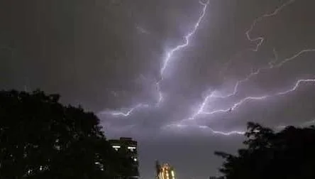
On Monday, Chandigarh saw a dramatic change in its weather pattern. The city recorded a small amount of rain, totaling about 1.7 mm. This was enough to push the daytime temperature down significantly. While Sunday was quite warm, Monday felt much cooler due to cloudy skies and moisture in the air. This shift marks the start of what experts call an "unsettled spell," where the weather does not stay the same for long and can change from sunny to stormy in a matter of hours.
Important Numbers and Facts
The temperature data shows just how sharp the cooling has been. In Chandigarh, the highest temperature on Monday was 27.3°C. This is more than 5 degrees lower than the previous day and about 4 degrees below what is normal for late March. Meanwhile, humidity levels were very high, starting at 89 percent in the morning and dropping to 64 percent by the afternoon. In the surrounding areas, Mohali saw a high of 31.9°C. Looking at the wider region, Faridkot in Punjab reached 33°C, and Nuh in Haryana recorded the highest temperature at 35.3°C. Since the start of March, Chandigarh has received a total of 25.1 mm of rain.
Background and Context
This type of weather is typical for the pre-monsoon season, which usually lasts from March until May. During this time, the sun begins to heat the ground intensely. This heat causes air to rise quickly, creating clouds that can lead to sudden thunderstorms. These are often called "convective" storms. They are different from the steady rains seen during the main monsoon season in July and August. Pre-monsoon storms are often short but can be very intense, bringing lightning and sudden gusts of wind. Understanding this pattern helps residents realize that while the rain is helpful for cooling the air, the accompanying wind and lightning require caution.
Public or Industry Reaction
Local residents have noticed the sudden shift in the air. Many people welcomed the cooler Monday afternoon after a few days of rising heat. However, the thunderstorm alerts have caused some concern for those who work outdoors or have to travel between Chandigarh, Mohali, and Panchkula. Traffic often slows down during these sudden rain spells, and the wind alerts serve as a reminder for people to secure loose items on balconies or rooftops. Farmers in the surrounding Punjab and Haryana regions are also keeping a close watch on these updates, as wind and rain at this time of year can affect crops that are nearing harvest.
What This Means Going Forward
The weather forecast for the rest of the week shows a mix of conditions. Tuesday is a high-alert day with a forecast of thunderstorms and lightning. Winds could be strong enough to cause minor disruptions. Wednesday will likely remain cloudy with a chance of light rain, but the intensity is expected to decrease. Thursday is predicted to be the warmest and driest day of the week, with temperatures climbing back up to 32°C. However, this dry patch will be short-lived. A second wave of stormy weather is expected to arrive on Friday and last through Sunday. During this weekend period, scattered rain and more thunderstorms are likely across both Punjab and the Chandigarh-Haryana border areas.
The current weather in the Tricity is a classic example of the unpredictable pre-monsoon period. While the lower temperatures provide a break from the sun, the threat of lightning and high winds remains real. Residents should stay informed by checking daily weather updates before planning long trips or outdoor events. Keeping an umbrella ready and being prepared for sudden wind gusts will help everyone stay safe during this unsettled week. The cooling trend is a positive sign for those worried about an early summer heatwave, but it requires a bit of extra care to navigate the storms.